


Pulaski Township Voting District, Morrison County, Minnesota
About
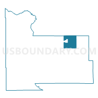
Outline

Summary
| Unique Area Identifier | 603206 |
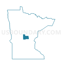
| Name | Pulaski Township Voting District |
| County | Morrison County |
| State | Minnesota |
| Area (square miles) | 32.35 |
| Land Area (square miles) | 31.01 |
| Water Area (square miles) | 1.34 |
| % of Land Area | 95.87 |
| % of Water Area | 4.13 |
| Latitude of the Internal Point | 46.09910980 |
| Longtitude of the Internal Point | -93.97777250 |
Maps

Graphs
Select a template below for downloading or customizing gragh for Pulaski Township Voting District, Morrison County, Minnesota


Neighbors
Neighoring Voting District (by Name) Neighboring Voting District on the Map
- Buh Township Voting District, Morrison County, MN
- Daggett Brook Twp. Voting District, Crow Wing County, MN
- Granite Township Voting District, Morrison County, MN
- Harding Voting District, Morrison County, MN
- Leigh Township Voting District, Morrison County, MN
- Platte Lake Twp. Voting District, Crow Wing County, MN
- Platte Township Voting District, Morrison County, MN
- Richardson Township Voting District, Morrison County, MN
- Roosevelt Twp. Voting District, Crow Wing County, MN
Top 10 Neighboring County Subdivision (by Population) Neighboring County Subdivision on the Map
- Roosevelt township, Crow Wing County, MN (601)
- Daggett Brook township, Crow Wing County, MN (554)
- Richardson township, Morrison County, MN (536)
- Buh township, Morrison County, MN (520)
- Granite township, Morrison County, MN (481)
- Platte Lake township, Crow Wing County, MN (414)
- Platte township, Morrison County, MN (357)
- Pulaski township, Morrison County, MN (300)
- Leigh township, Morrison County, MN (212)
- Harding city, Morrison County, MN (125)
Top 10 Neighboring Place (by Population) Neighboring Place on the Map
Top 10 Neighboring Unified School District (by Population) Neighboring Unified School District on the Map
- Brainerd Public School District, MN (42,588)
- Onamia Public School District, MN (5,676)
- Pierz Public School District, MN (5,240)
Top 10 Neighboring State Legislative District Lower Chamber (by Population) Neighboring State Legislative District Lower Chamber on the Map
Top 10 Neighboring State Legislative District Upper Chamber (by Population) Neighboring State Legislative District Upper Chamber on the Map
Top 10 Neighboring 111th Congressional District (by Population) Neighboring 111th Congressional District on the Map
Top 10 Neighboring Census Tract (by Population) Neighboring Census Tract on the Map
- Census Tract 9514, Crow Wing County, MN (5,002)
- Census Tract 9516, Crow Wing County, MN (2,584)
- Census Tract 7804, Morrison County, MN (2,580)